


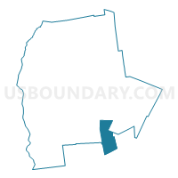
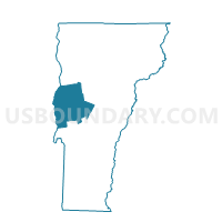
Goshen Voting District, Addison County, Vermont
About
Outline

Summary
| Unique Area Identifier | 680707 |
| Name | Goshen Voting District |
| County | Addison County |
| State | Vermont |
| Area (square miles) | 20.81 |
| Land Area (square miles) | 20.65 |
| Water Area (square miles) | 0.16 |
| % of Land Area | 99.22 |
| % of Water Area | 0.78 |
| Latitude of the Internal Point | 43.86467350 |
| Longtitude of the Internal Point | -72.99005240 |
Maps

Graphs
Select a template below for downloading or customizing gragh for Goshen Voting District, Addison County, Vermont


Neighbors
Neighoring Voting District (by Name) Neighboring Voting District on the Map
- Brandon Voting District, Rutland County, VT
- Chittenden Voting District, Rutland County, VT
- Hancock Voting District, Addison County, VT
- Leiscester Voting District, Addison County, VT
- Ripton Voting District, Addison County, VT
- Rochester Voting District, Windsor County, VT
- Salisbury Voting District, Addison County, VT
Top 10 Neighboring County Subdivision (by Population) Neighboring County Subdivision on the Map
- Brandon town, Rutland County, VT (3,966)
- Chittenden town, Rutland County, VT (1,258)
- Rochester town, Windsor County, VT (1,139)
- Salisbury town, Addison County, VT (1,136)
- Leicester town, Addison County, VT (1,100)
- Ripton town, Addison County, VT (588)
- Hancock town, Addison County, VT (323)
- Goshen town, Addison County, VT (164)
Top 10 Neighboring Elementary School District (by Population) Neighboring Elementary School District on the Map
- Brandon School District, VT (3,966)
- Barstow Joint Contract School District, VT (2,317)
- Salisbury School District, VT (1,136)
- Leicester School District, VT (1,100)
- Ripton School District, VT (588)
- Goshen School District, VT (164)
Top 10 Neighboring Secondary School District (by Population) Neighboring Secondary School District on the Map
- Middlebury Union High School District 3, VT (14,721)
- Otter Valley Union High School District 8, VT (9,200)
- Chittenden School District, VT (1,258)
Top 10 Neighboring Unified School District (by Population) Neighboring Unified School District on the Map
Top 10 Neighboring State Legislative District Lower Chamber (by Population) Neighboring State Legislative District Lower Chamber on the Map
- Addison-2 State House District, VT (4,496)
- Windsor-Rutland-2 State House District, VT (4,451)
- Rutland-Windsor-1 State House District, VT (4,064)
- Rutland-7 State House District, VT (3,966)
Top 10 Neighboring State Legislative District Upper Chamber (by Population) Neighboring State Legislative District Upper Chamber on the Map
- Rutland State Senate District, VT (57,676)
- Windsor State Senate District, VT (56,670)
- Addison State Senate District, VT (40,787)
Top 10 Neighboring 111th Congressional District (by Population) Neighboring 111th Congressional District on the Map
Top 10 Neighboring Census Tract (by Population) Neighboring Census Tract on the Map
- Census Tract 9622, Rutland County, VT (3,966)
- Census Tract 9652, Windsor County, VT (2,870)
- Census Tract 9606, Addison County, VT (2,644)
- Census Tract 9610, Addison County, VT (2,236)
- Census Tract 9621, Rutland County, VT (1,804)
Top 10 Neighboring 5-Digit ZIP Code Tabulation Area (by Population) Neighboring 5-Digit ZIP Code Tabulation Area on the Map
- 05733, VT (5,895)
- 05763, VT (2,747)
- 05769, VT (1,216)
- 05767, VT (1,143)
- 05737, VT (875)
- 05766, VT (572)
- 05748, VT (323)